
Thank you for supporting this site ❤️
Make a donation
Make a donation
Perené topographic map
Click on the map to display elevation.
Thank you for supporting this site ❤️
Make a donation
Make a donation
About this map
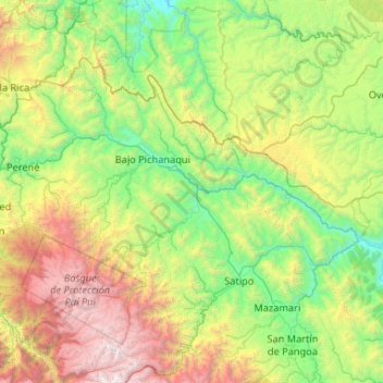
Name: Perené topographic map, elevation, terrain.
Location: Perené, Junín, Peru (-11.17056 -75.28270 -10.86142 -74.23104)
Average elevation: 1,507 m
Minimum elevation: 271 m
Maximum elevation: 4,899 m
Thank you for supporting this site ❤️
Make a donation
Make a donation
Other topographic maps
Click on a map to view its topography, its elevation and its terrain.
Thank you for supporting this site ❤️
Make a donation
Make a donation
Thank you for supporting this site ❤️
Make a donation
Make a donation