
Rasayani topographic map
Interactive map
Click on the map to display elevation.
About this map
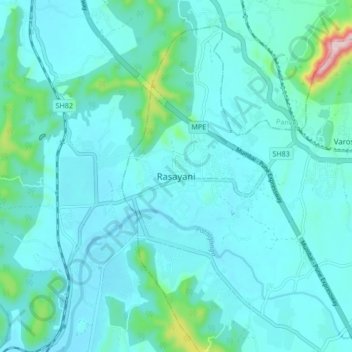
Name: Rasayani topographic map, elevation, terrain.
Location: Rasayani, Khalapur, Raigad, Maharashtra, 410222, India (18.85788 73.14036 18.93788 73.22036)
Average elevation: 48 m
Minimum elevation: 4 m
Maximum elevation: 382 m
Other topographic maps
Click on a map to view its topography, its elevation and its terrain.
Khopoli
India > Maharashtra > Khalapur
Khopoli, Mumbai Metropolitan Region, Khalapur, Raigad, Maharashtra, 410203, India
Average elevation: 223 m
Bid Khurd
India > Maharashtra > Khalapur > Bid Khurd
Bid Khurd, Mumbai Metropolitan Region, Khalapur, Raigad, Maharashtra, 41101, India
Average elevation: 144 m
Anandnagar
India > Maharashtra > Khalapur > Anandnagar
Anandnagar, Khalapur, Raigad, Maharashtra, India
Average elevation: 145 m