
Thank you for supporting this site ❤️
Make a donation
Make a donation
Gokul Thanda topographic map
Click on the map to display elevation.
Thank you for supporting this site ❤️
Make a donation
Make a donation
About this map
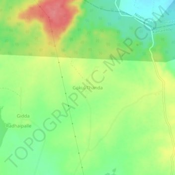
Name: Gokul Thanda topographic map, elevation, terrain.
Location: Gokul Thanda, Ramareddy mandal, Kamareddy, Telangana, India (18.42158 78.32817 18.46158 78.36817)
Average elevation: 523 m
Minimum elevation: 487 m
Maximum elevation: 568 m
Thank you for supporting this site ❤️
Make a donation
Make a donation