
Biebertal topographic map
Interactive map
Click on the map to display elevation.
About this map
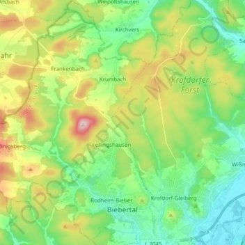
Name: Biebertal topographic map, elevation, terrain.
Location: Biebertal, Landkreis Gießen, Hessen, 35444, Deutschland (50.60306 8.51923 50.69910 8.62727)
Average elevation: 269 m
Minimum elevation: 154 m
Maximum elevation: 500 m
Other topographic maps
Click on a map to view its topography, its elevation and its terrain.
Villingen
Deutschland > Hessen > Landkreis Gießen
Villingen, Hungen, Landkreis Gießen, Hessen, Deutschland
Average elevation: 193 m
Pohlheim
Deutschland > Hessen > Landkreis Gießen
Pohlheim, Landkreis Gießen, Hessen, 35415, Deutschland
Average elevation: 218 m
Langgöns
Deutschland > Hessen > Landkreis Gießen
Langgöns, Landkreis Gießen, Hessen, 35428, Deutschland
Average elevation: 261 m