
Birnhorn topographic map
Interactive map
Click on the map to display elevation.
About this map
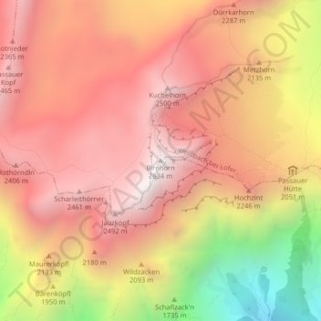
Name: Birnhorn topographic map, elevation, terrain.
Average elevation: 2,030 m
Minimum elevation: 1,064 m
Maximum elevation: 2,579 m
Other topographic maps
Click on a map to view its topography, its elevation and its terrain.
Leoganger Steinberge
Österreich > Salzburg > Weißbach bei Lofer
Leoganger Steinberge, Weißbach bei Lofer, Zell am See, Salzburg, 5093, Österreich
Average elevation: 1,283 m