
Ronda topographic map
Interactive map
Click on the map to display elevation.
About this map
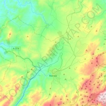
Name: Ronda topographic map, elevation, terrain.
Location: Ronda, Serranía de Ronda, Malaga, Andalousie, Espagne (36.67008 -5.29527 36.92104 -4.99532)
Average elevation: 801 m
Minimum elevation: 360 m
Maximum elevation: 1,793 m
Other topographic maps
Click on a map to view its topography, its elevation and its terrain.
Jubrique
Espagne > Andalousie > Serranía de Ronda
Jubrique, Serranía de Ronda, Malaga, Andalousie, 29492, Espagne
Average elevation: 599 m
Benarrabá
Espagne > Andalousie > Serranía de Ronda > Benarrabá
Benarrabá, Serranía de Ronda, Malaga, Andalousie, Espagne
Average elevation: 482 m