
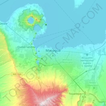
Managua topographic map
Interactive map
Click on the map to display elevation.
About this map
Name: Managua topographic map, elevation, terrain.
Average elevation: 194 m
Minimum elevation: 36 m
Maximum elevation: 935 m
Managua, due to its tropical climate, varied topography, naturally fertile soils, and abundant rain and water sources, boasts a great variety of flora. Many different types of trees, some of which are not found elsewhere in the world, appear, including chilamates, ceibos, pochotes, genízaros, tigüilotes, royal palms, piñuelas and madroños (Nicaragua's national tree) surround the city. During the rainy season (May to November), Managua becomes a lush city due to many palms, bushes, and other plants and trees which dominate the city's appearance.
Other topographic maps
Click on a map to view its topography, its elevation and its terrain.
El Boquete (Sector Norte Santo Domingo)
Nicaragua > Departamento de Managua > Managua
El Boquete (Sector Norte Santo Domingo), District I, Managua, Managua (Municipio), Departamento de Managua, 14234, Nicaragua
Average elevation: 250 m
Francisco Morazán
Nicaragua > Departamento de Managua > Managua
Francisco Morazán, D2, Managua, Managua (Municipio), Departamento de Managua, 12012, Nicaragua
Average elevation: 64 m