
Thank you for supporting this site ❤️
Make a donation
Make a donation
120 topographic map
Click on the map to display elevation.
Thank you for supporting this site ❤️
Make a donation
Make a donation
About this map
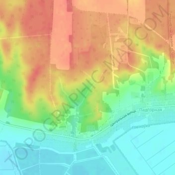
Name: 120 topographic map, elevation, terrain.
Average elevation: 166 m
Minimum elevation: 134 m
Maximum elevation: 199 m
Thank you for supporting this site ❤️
Make a donation
Make a donation
Other topographic maps
Click on a map to view its topography, its elevation and its terrain.
Добрый Бор
Беларусь > Брестская область > Барановичский район > Подгорновский сельский Совет
Average elevation: 152 m
Колбовичи
Беларусь > Брестская область > Барановичский район > Подгорновский сельский Совет
Average elevation: 152 m
Рыжовка
Беларусь > Брестская область > Барановичский район > Подгорновский сельский Совет
Average elevation: 171 m
Ежона
Беларусь > Брестская область > Барановичский район > Подгорновский сельский Совет
Average elevation: 160 m
Thank you for supporting this site ❤️
Make a donation
Make a donation