
Thank you for supporting this site ❤️
Make a donation
Make a donation
Trecynon topographic map
Click on the map to display elevation.
Thank you for supporting this site ❤️
Make a donation
Make a donation
About this map
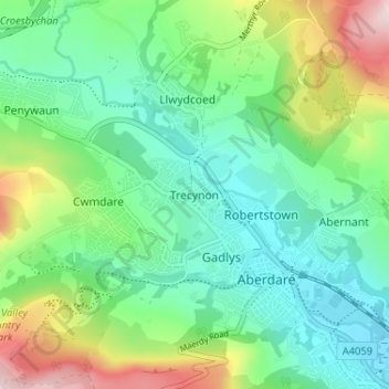
Name: Trecynon topographic map, elevation, terrain.
Location: Trecynon, Rhondda Cynon Taf, Wales, CF44 8LY, United Kingdom (51.70204 -3.47753 51.74204 -3.43753)
Average elevation: 212 m
Minimum elevation: 114 m
Maximum elevation: 444 m
Thank you for supporting this site ❤️
Make a donation
Make a donation
Other topographic maps
Click on a map to view its topography, its elevation and its terrain.
Thank you for supporting this site ❤️
Make a donation
Make a donation
Thank you for supporting this site ❤️
Make a donation
Make a donation