
Thank you for supporting this site ❤️
Make a donation
Make a donation
Pitahaya topographic map
Click on the map to display elevation.
Thank you for supporting this site ❤️
Make a donation
Make a donation
About this map
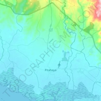
Name: Pitahaya topographic map, elevation, terrain.
Location: Pitahaya, Puntarenas, Puntarenas Province, 60102, Costa Rica (9.98546 -84.89693 10.10470 -84.77859)
Average elevation: 41 m
Minimum elevation: 0 m
Maximum elevation: 356 m
Thank you for supporting this site ❤️
Make a donation
Make a donation
Other topographic maps
Click on a map to view its topography, its elevation and its terrain.