Geolocate

Romilly-sur-Aigre topographic map

Interactive map

Click on the map to display elevation.

About this map

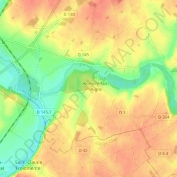
Name: Romilly-sur-Aigre topographic map, elevation, terrain.

Location: Romilly-sur-Aigre, Cloyes-les-Trois-Rivières, Châteaudun, Eure-et-Loir, Centre-Val de Loire, France métropolitaine, 28220, France (47.96148 1.24796 47.99732 1.32091)

Average elevation: 118 m

Minimum elevation: 90 m

Maximum elevation: 137 m

Other topographic maps

Click on a map to view its topography, its elevation and its terrain.

Autheuil

France > Centre-Val de Loire > Eure-et-Loir > Cloyes-les-Trois-Rivières

Autheuil, Cloyes-les-Trois-Rivières, Châteaudun, Eure-et-Loir, Centre-Val de Loire, France métropolitaine, 28220, France

Average elevation: 123 m

Saint-Hilaire-sur-Yerre

France > Centre-Val de Loire > Eure-et-Loir > Cloyes-les-Trois-Rivières

Saint-Hilaire-sur-Yerre, Cloyes-les-Trois-Rivières, Châteaudun, Eure-et-Loir, Centre-Val de Loire, France métropolitaine, 28220, France

Average elevation: 135 m

Charray

France > Centre-Val de Loire > Eure-et-Loir > Cloyes-les-Trois-Rivières

Charray, Cloyes-les-Trois-Rivières, Châteaudun, Eure-et-Loir, Centre-Val de Loire, France métropolitaine, 28220, France

Average elevation: 124 m

Cloyes-sur-le-Loir

France > Centre-Val de Loire > Eure-et-Loir > Cloyes-les-Trois-Rivières

Cloyes-sur-le-Loir, Cloyes-les-Trois-Rivières, Châteaudun, Eure-et-Loir, Centre-Val de Loire, France métropolitaine, 28220, France

Average elevation: 127 m

La Ferandière

France > Centre-Val de Loire > Eure-et-Loir > Cloyes-les-Trois-Rivières

La Ferandière, Autheuil, Cloyes-les-Trois-Rivières, Châteaudun, Eure-et-Loir, Centre-Val de Loire, France métropolitaine, 28220, France

Average elevation: 129 m