
Thank you for supporting this site ❤️
Make a donation
Make a donation
Stalden (Sarnen) topographic map
Click on the map to display elevation.
Thank you for supporting this site ❤️
Make a donation
Make a donation
About this map
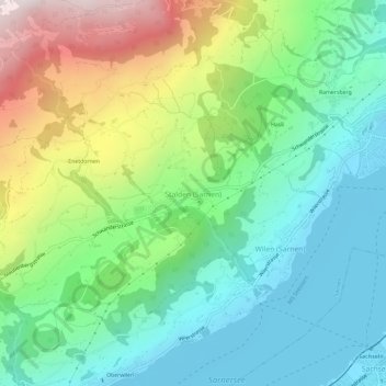
Name: Stalden (Sarnen) topographic map, elevation, terrain.
Location: Stalden (Sarnen), Sarnen, Obwalden, 6063, Schweiz (46.86702 8.19135 46.90702 8.23135)
Average elevation: 784 m
Minimum elevation: 467 m
Maximum elevation: 1,469 m
Thank you for supporting this site ❤️
Make a donation
Make a donation
Other topographic maps
Click on a map to view its topography, its elevation and its terrain.
Sarnersee
Schweiz > Obwalden > Sarnen > Sachseln
Der Sarnersee ist ein 7,5 km² grosser See in der Zentralschweiz im Kanton Obwalden. Er erstreckt sich in Südwest-Nordost-Richtung, ist ungefähr 6 km lang und hat eine mittlere Breite von 1,3 km. Die mittlere Seehöhe liegt auf 469 m ü. M., der tiefste Punkt des Seegrundes auf 418 m ü. M., was einer…
Average elevation: 601 m