
Thank you for supporting this site ❤️
Make a donation
Make a donation
Sydney topographic map
Click on the map to display elevation.
Thank you for supporting this site ❤️
Make a donation
Make a donation
Sydney
Sydney is on the east bank of the Sydney River where it discharges into South Arm of Sydney Harbour. Elevation ranges from sea level to 66 m (217 ft) above sea level.
Thank you for supporting this site ❤️
Make a donation
Make a donation
About this map
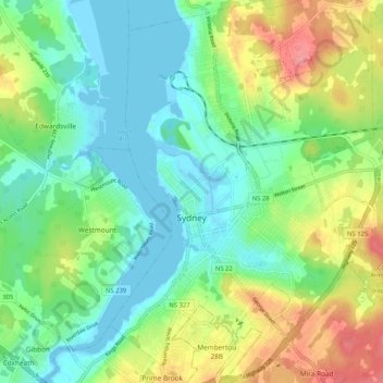
Name: Sydney topographic map, elevation, terrain.
Average elevation: 30 m
Minimum elevation: -5 m
Maximum elevation: 88 m
Thank you for supporting this site ❤️
Make a donation
Make a donation
Other topographic maps
Click on a map to view its topography, its elevation and its terrain.
Margaret Boone Memorial Park
Canada > Nova Scotia > Cape Breton Regional Municipality > Dominion
Average elevation: 13 m