
Thank you for supporting this site ❤️
Make a donation
Make a donation
Weißenfeld topographic map
Click on the map to display elevation.
Thank you for supporting this site ❤️
Make a donation
Make a donation
About this map
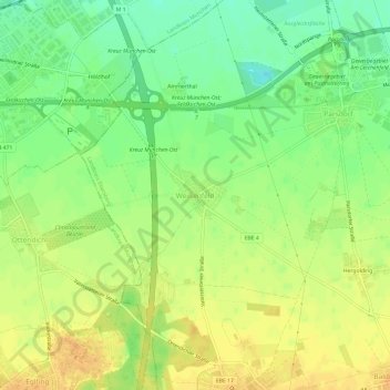
Name: Weißenfeld topographic map, elevation, terrain.
Average elevation: 532 m
Minimum elevation: 514 m
Maximum elevation: 546 m
Thank you for supporting this site ❤️
Make a donation
Make a donation
Other topographic maps
Click on a map to view its topography, its elevation and its terrain.
85598
Deutschland > Bayern > Landkreis Ebersberg > Vaterstetten > Baldham Dorf
Average elevation: 542 m