
Barßel topographic map
Interactive map
Click on the map to display elevation.
About this map
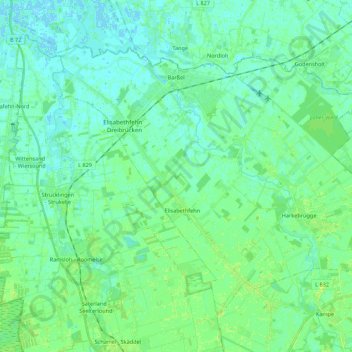
Name: Barßel topographic map, elevation, terrain.
Average elevation: 4 m
Minimum elevation: -2 m
Maximum elevation: 10 m
Other topographic maps
Click on a map to view its topography, its elevation and its terrain.
Saterland - Seelterlound
Allemagne > Basse-Saxe > Cloppenbourg (arrondissement) > Saterland - Seelterlound
Saterland - Seelterlound, Cloppenbourg (arrondissement), Basse-Saxe, 26683, Allemagne
Average elevation: 5 m
Cloppenburg
Allemagne > Basse-Saxe > Cloppenbourg (arrondissement)
Cloppenburg, Cloppenbourg (arrondissement), Basse-Saxe, 49661, Allemagne
Average elevation: 41 m