
Make a donation
Cahul topographic map
Click on the map to display elevation.
Make a donation
About this map
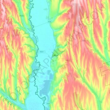
Name: Cahul topographic map, elevation, terrain.
Location: Cahul, Cahul District, MD-3902, Moldova (45.74441 28.03466 46.06441 28.35466)
Average elevation: 101 m
Minimum elevation: 2 m
Maximum elevation: 250 m
Make a donation
Other topographic maps
Click on a map to view its topography, its elevation and its terrain.
Make a donation
Make a donation
Cimișlia District
The district is located in the southern Republic of Moldova. It is bordered by Hîncești District and Ialoveni District on the north, Căușeni District on the east and Gagauzia, Basarabeasca District and the Ukraine border on the south. The northern part of the district is hilly, where the Central Moldavian…
Average elevation: 157 m
Make a donation
Make a donation
Make a donation
Make a donation
Make a donation
Briceni District
Located in the extreme northwest of the Republic of Moldova, the district borders Ukraine in the north, Ocnița District in the east, Edineț District in the south, and Romania in the west, across the river Prut. Criva village located in the district is the western point of the Republic of Moldova coordinates:…
Average elevation: 206 m
Ocnița District
In general, the terrain is characterized by plains and gentle hills. Over the many little rivers, valleys landforms gets injured. Here come the daylight limestone rocks, forming rocky areas, called Toltre. In district is extracted precious building materials: limestone, quartz sand, clay shale. The maximum…
Average elevation: 222 m
Make a donation
Dondușeni District
Donduşeni district is located in the north-eastern part of Moldova, with neighboring districts- Ocnița District in the north, Edineţ District in the west, Rîșcani District in the south, Drochia and Soroca in the southeast. Also, it has a border with Ukraine in the northeast. Chernozems occupy 80% of the…
Average elevation: 210 m
Drochia
Drochia (Romanian pronunciation: [ˈdroki.ja]) is a city in the northern part of Moldova. It is the administrative center of the eponymous district. The city is located 174.4 km (108.4 mi) north of the national capital, Chișinău, and 67 km (42 mi) north-east of the Romanian city of Iași. The average…
Average elevation: 201 m
Rîșcani District
Located in northern Moldova, the district borders Edineț and Dondușeni to the north, Drochia and Sîngerei to the east, Municipality of Bălți and Glodeni to the south, and Romania to the west. The district is located on the Northern Moldavian Plateau, characterized by gently undulating relief and weak…
Average elevation: 165 m
Make a donation
Șoldănești District
The Șoldănești district is located in north-eastern Moldova. It neighbors to north and west the Florești District, in the north-east the Camenca District, in the east the Rîbnița District, and in the south the Telenești and Rezina districts. The territory is located within the Dniester Plateau, the…
Average elevation: 197 m
Florești District
Floresti district (http://floresti.md) is located in north-eastern part of Moldova and is bordered to the north Soroca District, north-west Drochia District, Telenesti District to the south, east to Camenca District, south-east Soldanesti District and west with Singerei District. Landscape is fragmented in…
Average elevation: 171 m
Glodeni District
Glodeni District is bordered by Riscani District on the north, Balti Municipality on the east, Falesti District on the south and Romania on the west. The district is a hilly plain, fragmented by valleys which are higher in the west with a slight incline to their merge with the Prut. In the western part of the…
Average elevation: 138 m
Make a donation
Sîngerei District
Singerei district is located in the north of Moldova has neighborhood the Drochia District in north, east Floreşti District, Ungheni District in the southwest district, Teleneşti District south, west Făleşti District and Bălți municipality in northwest. Geographically, it situated in Balti steppe and is…
Average elevation: 149 m
Cahul District
Cahul district is located in the southern part of the Republic of Moldova. The district is located in the extreme southern point of Moldova in Giurgiulești village. Cantemir District is in the north, Gagauzia in the northeast, Taraclia District in the east, the border of Ukraine in the south and Romania in…
Average elevation: 99 m
Ștefan Vodă District
Ștefan Vodă district is located in south-eastern part of the Republic of Moldova. It is bordered by Căușeni District in the northwest, Slobozia District in the northeast, and the state border with Ukraine in the south and east. The landscape is predominantly plain, slightly fractured, the highest altitude…
Average elevation: 90 m
Make a donation
Cantemir District
Cantemir district is located in the south part of the Republic of Moldova. Neighborhood has the following districts: Leova District in north, east Gagauzia, Cahul District in southern and border state in west to Romania, on the river Prut. The relief is generally hilly plain with the maximum altitude is 301 m…
Average elevation: 119 m
Leova District
Leova District is located in the southwest part of the Republic of Moldova. Its neighbors are as follows: Hîncești District in the north, Gagauzia and Cimișlia District in the east, Cantemir District in the south, and the state border with Romania in the west, on the river Prut. The relief is generally…
Average elevation: 117 m
Basarabeasca District
District is located in the southern part of the Republic of Moldova. Neighborhood has the following district: north Cimislia District, the east boundary of the state with Ukraine, in the west and south bordering of Gagauzia. Also the district is the smallest area and population of Moldova was. The landscape of…
Average elevation: 138 m
Make a donation
Anenii Noi District
Anenii Noi District is located in the central part of Moldova. Neighborhood has the following district: Criuleni District in north, east Grigoriopol District, Căuşeni District in south, Ialoveni District and Municipality of Chişinău in the west. Flat relief, the plain. Altitudes range from 30 m in the…
Average elevation: 94 m
Criuleni District
Criuleni District is located in the central part of Moldova. Does the neighborhood: in the north Orhei District, Dubăsari District in the east, south Anenii Noi District, in western Municipality of Chișinău, and Strășeni District. District is located within the eastern extremity of Central Moldavian…
Average elevation: 122 m
Make a donation
Make a donation
Make a donation
Make a donation
Make a donation
Administrative-Territorial Units of the Left Bank of the Dniester
Average elevation: 148 m
Make a donation
Make a donation
Căușeni District
Căușeni District is located in the southern part of Moldova. It is bordered by the following districts: Ialoveni and Anenii Noi in the north, Slobozia District in the east, Ștefan Vodă District in the south-east, bordering in the south with Ukraine, and Cimișlia District in the west. The relief of the…
Average elevation: 119 m
Make a donation
Make a donation
Make a donation
Make a donation
Make a donation
Make a donation