
84400 topographic map
Interactive map
Click on the map to display elevation.
About this map
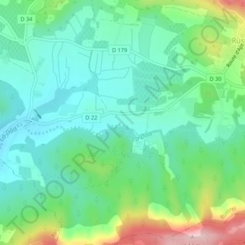
Name: 84400 topographic map, elevation, terrain.
Average elevation: 354 m
Minimum elevation: 282 m
Maximum elevation: 537 m
Other topographic maps
Click on a map to view its topography, its elevation and its terrain.
Bouvène
France > Provence-Alpes-Côte d'Azur > Vaucluse > Rustrel
Bouvène, Rustrel, Apt, Vaucluse, Provence-Alpes-Côte d'Azur, France métropolitaine, 84400, France
Average elevation: 474 m
Le Colorado Provençal
France > Provence-Alpes-Côte d'Azur > Vaucluse > Rustrel
Le Colorado Provençal, Chemin de Saint-Joseph, Rustrel, Apt, Vaucluse, Provence-Alpes-Côte d'Azur, France métropolitaine, 84400, France
Average elevation: 440 m