
Vinge topographic map
Interactive map
Click on the map to display elevation.
About this map
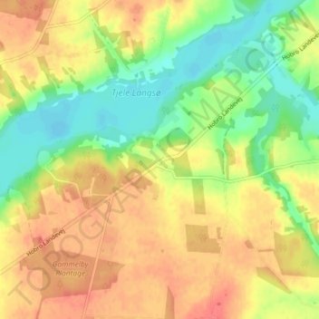
Name: Vinge topographic map, elevation, terrain.
Location: Vinge, Viborg Kommune, Region Mitteljütland, Dänemark (56.51039 9.64063 56.55039 9.68063)
Average elevation: 35 m
Minimum elevation: 6 m
Maximum elevation: 59 m
Other topographic maps
Click on a map to view its topography, its elevation and its terrain.
Aarhus
Dänemark > Region Mitteljütland
Aarhus, Aarhus Kommune, Region Mitteljütland, 8000, Dänemark
Average elevation: 35 m
Region Mitteljütland
Dänemark > Region Mitteljütland
Region Mitteljütland, Dänemark
Average elevation: 19 m