
Make a donation
Elizabeth Heights topographic map
Click on the map to display elevation.
Make a donation
About this map
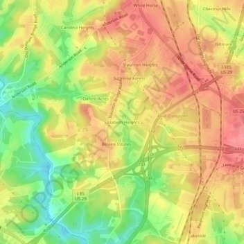
Name: Elizabeth Heights topographic map, elevation, terrain.
Average elevation: 280 m
Minimum elevation: 236 m
Maximum elevation: 310 m
Make a donation
Other topographic maps
Click on a map to view its topography, its elevation and its terrain.
Greenville
United States > South Carolina > Greenville County
Greenville features a varied topography characterized by rolling hills and the nearby Blue Ridge Mountains. The city sits at an elevation of approximately 984 feet (300 meters) above sea level, with its landscape shaped significantly by the Reedy River, which flows through the heart of downtown, creating…
Average elevation: 290 m
Make a donation
Slater-Marietta
United States > South Carolina > Greenville County > Slater-Marietta
Average elevation: 325 m
Simpsonville
United States > South Carolina > Greenville County
Simpsonville is located in southeastern Greenville County at 34°44′0″N 82°15′36″W / 34.73333°N 82.26000°W / 34.73333; -82.26000 (34.733375, -82.260001), between Mauldin to the northwest and Fountain Inn to the southeast. The center of town has an elevation of 866 feet (264 m) above sea level.
Average elevation: 259 m
Make a donation
Make a donation
Mountain Bridge Wilderness Area
United States > South Carolina > Greenville County
Average elevation: 680 m
Make a donation
Make a donation
Make a donation
Make a donation
Simpsonville
United States > South Carolina > Greenville County
Simpsonville is located in southeastern Greenville County at 34°44′0″N 82°15′36″W / 34.73333°N 82.26000°W / 34.73333; -82.26000 (34.733375, -82.260001), between Mauldin to the northwest and Fountain Inn to the southeast. The center of town has an elevation of 866 feet (264 m) above sea level.
Average elevation: 258 m