
Thank you for supporting this site ❤️
Make a donation
Make a donation
Clotte topographic map
Click on the map to display elevation.
Thank you for supporting this site ❤️
Make a donation
Make a donation
About this map
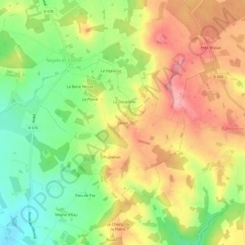
Name: Clotte topographic map, elevation, terrain.
Average elevation: 174 m
Minimum elevation: 111 m
Maximum elevation: 235 m
Thank you for supporting this site ❤️
Make a donation
Make a donation
Other topographic maps
Click on a map to view its topography, its elevation and its terrain.
Beaumont-du-Périgord
France > Nouvelle-Aquitaine > Dordogne > Beaumontois en Périgord
Average elevation: 134 m
Beaumont-du-Périgord
France > Nouvelle-Aquitaine > Dordogne > Beaumontois en Périgord
Average elevation: 134 m
Sainte-Sabine-Born
France > Nouvelle-Aquitaine > Dordogne > Beaumontois en Périgord
Average elevation: 134 m
Thank you for supporting this site ❤️
Make a donation
Make a donation