
Make a donation
Mount Chōkai topographic map
Click on the map to display elevation.
Make a donation
Mount Chōkai
Mount Chōkai is shared by two municipalities in Akita Prefecture and four municipalities Yamagata Prefecture; however, its peak is located in Yuza, on the Yamagata side of the border. It is therefore the highest peak in Yamagata, and the second highest in the Tōhoku region after Mt. Hiuchigatake (altitude 2,356 m). The highest elevation of Mount Chōkai within Akita Prefecture has an altitude of 1,775 meters, and thus the mountain is also the highest in Akita Prefecture. From the summit, it is possible to see the Shirakami Mountains and Mount Iwaki to the north, Sado Island to the south and the Pacific Ocean to the east.
Make a donation
About this map
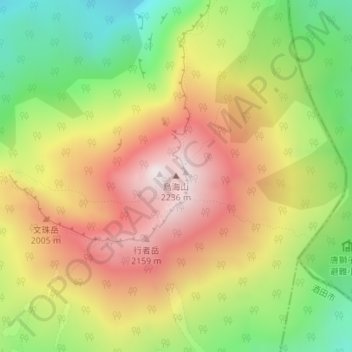
Name: Mount Chōkai topographic map, elevation, terrain.
Location: Mount Chōkai, Yuza, Akumi County, Yamagata Prefecture, Japan (39.09920 140.05030 39.09930 140.05040)
Average elevation: 1,808 m
Minimum elevation: 1,387 m
Maximum elevation: 2,221 m
Make a donation