
Thank you for supporting this site ❤️
Make a donation
Make a donation
Felguerina topographic map
Click on the map to display elevation.
Thank you for supporting this site ❤️
Make a donation
Make a donation
About this map
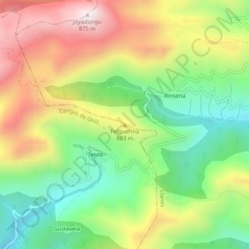
Name: Felguerina topographic map, elevation, terrain.
Location: Felguerina, Cangas de Onís, Asturias, España (43.39702 -5.01436 43.39712 -5.01426)
Average elevation: 500 m
Minimum elevation: 217 m
Maximum elevation: 855 m
Thank you for supporting this site ❤️
Make a donation
Make a donation
Other topographic maps
Click on a map to view its topography, its elevation and its terrain.
Cangas de Onís
España > Asturias > Cangas de Onís
Su cota máxima de altitud la encontramos en la Torre de Santa María o Peña Santa de Enol con 2478 metros de altitud sobre el nivel del mar.
Average elevation: 587 m