
Virginia Beach topographic map
Interactive map
Click on the map to display elevation.
Virginia Beach
According to the United States Census Bureau, the city has a total area of 497 square miles (1,290 km2), of which 249 square miles (640 km2) is land and 248 square miles (640 km2) (49.9%) is water. It is the largest city in Virginia by total area and third-largest city by land area. The average elevation is 12 feet (3.7 m) above sea level. A major portion of the city drains to the Chesapeake Bay by way of the Lynnhaven River and its tributaries.
About this map
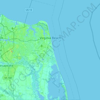
Name: Virginia Beach topographic map, elevation, terrain.
Location: Virginia Beach, Virginia, United States (36.55041 -76.22824 37.03025 -75.83190)
Average elevation: 2 m
Minimum elevation: -10 m
Maximum elevation: 41 m
Other topographic maps
Click on a map to view its topography, its elevation and its terrain.