
Pallejà topographic map
Interactive map
Click on the map to display elevation.
About this map
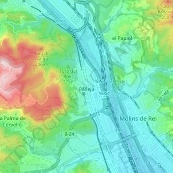
Name: Pallejà topographic map, elevation, terrain.
Location: Pallejà, Baix Llobregat, Barcelona, Catalunha, Espanha (41.40580 1.94464 41.43982 2.00939)
Average elevation: 97 m
Minimum elevation: 14 m
Maximum elevation: 330 m
Other topographic maps
Click on a map to view its topography, its elevation and its terrain.
Sant Just Desvern
Espanha > Catalunha > Baix Llobregat
Sant Just Desvern, Baix Llobregat, Barcelona, Catalunha, Espanha
Average elevation: 158 m
el Prat de Llobregat
Espanha > Catalunha > Baix Llobregat > el Prat de Llobregat
el Prat de Llobregat, Baix Llobregat, Barcelona, Catalunha, 08820, Espanha
Average elevation: 5 m
Sant Boi de Llobregat
Espanha > Catalunha > Baix Llobregat
Sant Boi de Llobregat, Baix Llobregat, Barcelona, Catalunha, 08830, Espanha
Average elevation: 34 m