
Thank you for supporting this site ❤️
Make a donation
Make a donation
Kogi State topographic map
Click on the map to display elevation.
Thank you for supporting this site ❤️
Make a donation
Make a donation
About this map
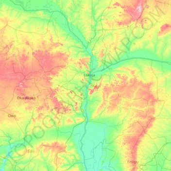
Name: Kogi State topographic map, elevation, terrain.
Location: Kogi State, Nigeria (6.53236 5.32150 8.73879 7.86626)
Average elevation: 210 m
Minimum elevation: 9 m
Maximum elevation: 887 m
Thank you for supporting this site ❤️
Make a donation
Make a donation
Other topographic maps
Click on a map to view its topography, its elevation and its terrain.