
Thank you for supporting this site ❤️
Make a donation
Make a donation
La Chapelle topographic map
Click on the map to display elevation.
Thank you for supporting this site ❤️
Make a donation
Make a donation
About this map
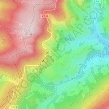
Name: La Chapelle topographic map, elevation, terrain.
Average elevation: 901 m
Minimum elevation: 695 m
Maximum elevation: 1,132 m
Thank you for supporting this site ❤️
Make a donation
Make a donation
Other topographic maps
Click on a map to view its topography, its elevation and its terrain.
Réserve biologique dirigée des Deux Lacs
France > Grand Est > Haut-Rhin > Le Bonhomme
Average elevation: 1,119 m