
Make a donation
McKenna topographic map
Click on the map to display elevation.
Make a donation
About this map
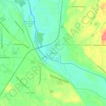
Name: McKenna topographic map, elevation, terrain.
Location: McKenna, Pierce County, Washington, 98558, United States (46.91482 -122.57651 46.95482 -122.53651)
Average elevation: 109 m
Minimum elevation: 81 m
Maximum elevation: 158 m
Make a donation
Other topographic maps
Click on a map to view its topography, its elevation and its terrain.
Tacoma
United States > Washington > Pierce County
Tacoma is at 47°14′29″N 122°27′34″W / 47.24139°N 122.45944°W / 47.24139; -122.45944 (47.241371, −122.459389). Its official elevation is 381 feet (116 m), varying between sea level and about 500 feet (150 m).
Average elevation: 67 m
Tacoma
United States > Washington > Pierce County
Tacoma is at 47°14′29″N 122°27′34″W / 47.24139°N 122.45944°W / 47.24139; -122.45944 (47.241371, −122.459389). Its official elevation is 381 feet (116 m), varying between sea level and about 500 feet (150 m).
Average elevation: 67 m
Make a donation
Tacoma
United States > Washington > Pierce County
Tacoma is at 47°14′29″N 122°27′34″W / 47.24139°N 122.45944°W / 47.24139; -122.45944 (47.241371, −122.459389). Its official elevation is 381 feet (116 m), varying between sea level and about 500 feet (150 m).
Average elevation: 67 m
Mount Rainier National Park
United States > Washington > Pierce County
Mount Rainier National Park is an American national park located in southeast Pierce County and northeast Lewis County in Washington state. The park was established on March 2, 1899 as the fifth national park in the United States, preserving 236,381 acres (369.3 sq mi; 956.6 km2) including all of Mount…
Average elevation: 1,412 m
Make a donation
Make a donation
Puyallup
United States > Washington > Pierce County
Downtown Puyallup and nearby neighborhoods lie within the hazard zone for lahars that could be produced in a moderate or large eruption of nearby Mount Rainier. The city's position on the Puyallup River is downstream of the western flank of Mount Rainier, which has the highest potential for producing…
Average elevation: 67 m
Make a donation
Make a donation
Puyallup
United States > Washington > Pierce County
Downtown Puyallup and nearby neighborhoods lie within the hazard zone for lahars that could be produced in a moderate or large eruption of nearby Mount Rainier. The city's position on the Puyallup River is downstream of the western flank of Mount Rainier, which has the highest potential for producing…
Average elevation: 67 m
Make a donation
Tacoma
United States > Washington > Pierce County
Tacoma has an official elevation of 381 feet (116 m), varying between sea level and about 500 feet (150 m).
Average elevation: 67 m
Make a donation
Make a donation
Make a donation
Make a donation
Make a donation
Puyallup
United States > Washington > Pierce County
Downtown Puyallup and nearby neighborhoods lie within the hazard zone for lahars that could be produced in a moderate or large eruption of nearby Mount Rainier. The city's position on the Puyallup River is downstream of the western flank of Mount Rainier, which has the highest potential for producing…
Average elevation: 67 m
Tacoma
United States > Washington > Pierce County
Tacoma is at 47°14′29″N 122°27′34″W / 47.24139°N 122.45944°W / 47.24139; -122.45944 (47.241371, −122.459389). Its official elevation is 381 feet (116 m), varying between sea level and about 500 feet (150 m).
Average elevation: 67 m
Make a donation
Make a donation
Make a donation
Greenwater
United States > Washington > Pierce County
Greenwater is located at the confluence of the Greenwater and White Rivers, at an approximate elevation of 1,700 feet (520 m) above sea level.
Average elevation: 655 m
Make a donation
Make a donation
Puyallup
United States > Washington > Pierce County
Downtown Puyallup and nearby neighborhoods lie within the hazard zone for lahars that could be produced in a moderate or large eruption of nearby Mount Rainier. The city's position on the Puyallup River is downstream of the western flank of Mount Rainier, which has the highest potential for producing…
Average elevation: 67 m
Make a donation
Make a donation
Tacoma
United States > Washington > Pierce County
Tacoma has an official elevation of 381 feet (116 m), varying between sea level and about 500 feet (150 m).
Average elevation: 67 m
Make a donation
Make a donation