
Thank you for supporting this site ❤️
Make a donation
Make a donation
Wegfurt topographic map
Click on the map to display elevation.
Thank you for supporting this site ❤️
Make a donation
Make a donation
Wegfurt
Das Pfarrdorf liegt circa sechs Kilometer südöstlich von Bischofsheim in der Rhön im Tal der Brend auf einer Höhe von 348 m ü. NHN. Etwa neun Kilometer nordöstlich verläuft die Landesgrenze zu Hessen. Die Bundesstraße 279 umgeht den Ortskern auf der nordöstlichen Seite.
Thank you for supporting this site ❤️
Make a donation
Make a donation
About this map
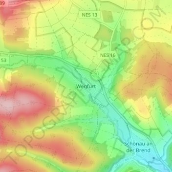
Name: Wegfurt topographic map, elevation, terrain.
Average elevation: 396 m
Minimum elevation: 305 m
Maximum elevation: 499 m
Thank you for supporting this site ❤️
Make a donation
Make a donation
Other topographic maps
Click on a map to view its topography, its elevation and its terrain.
97653
Deutschland > Bayern > Landkreis Rhön-Grabfeld > Bischofsheim in der Rhön
Average elevation: 615 m