
Thank you for supporting this site ❤️
Make a donation
Make a donation
Eikamp topographic map
Click on the map to display elevation.
Thank you for supporting this site ❤️
Make a donation
Make a donation
Eikamp
Die Topographia Ducatus Montani des Erich Philipp Ploennies, Blatt Amt Miselohe, belegt, dass der Wohnplatz 1715 als zwei Höfe kategorisiert wurde und mit Eikamp bezeichnet wurde.
Thank you for supporting this site ❤️
Make a donation
Make a donation
About this map
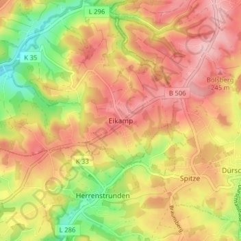
Name: Eikamp topographic map, elevation, terrain.
Average elevation: 192 m
Minimum elevation: 104 m
Maximum elevation: 255 m
Thank you for supporting this site ❤️
Make a donation
Make a donation
Other topographic maps
Click on a map to view its topography, its elevation and its terrain.
Scherfbachtal
Deutschland > Nordrhein-Westfalen > Rheinisch-Bergischer Kreis > Odenthal > Höffe
Average elevation: 165 m
Unterbreidbach
Deutschland > Nordrhein-Westfalen > Rheinisch-Bergischer Kreis > Odenthal > Neschen > Unterbreidbach
Average elevation: 198 m