
Thank you for supporting this site ❤️
Make a donation
Make a donation
Gooty topographic map
Click on the map to display elevation.
Thank you for supporting this site ❤️
Make a donation
Make a donation
Gooty
Gooty is located at 15°07′N 77°38′E / 15.12°N 77.63°E / 15.12; 77.63, at a distance of 52 km from Anantapur. It has an average elevation of 345 metres (1131 feet).
Thank you for supporting this site ❤️
Make a donation
Make a donation
About this map
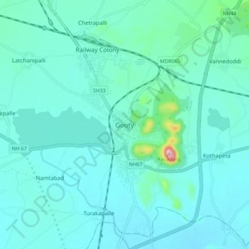
Name: Gooty topographic map, elevation, terrain.
Location: Gooty, Anantapur, Andhra Pradesh, 515401, India (15.08279 77.59601 15.16279 77.67601)
Average elevation: 364 m
Minimum elevation: 329 m
Maximum elevation: 624 m
Thank you for supporting this site ❤️
Make a donation
Make a donation