
Thank you for supporting this site ❤️
Make a donation
Make a donation
Kano topographic map
Click on the map to display elevation.
Thank you for supporting this site ❤️
Make a donation
Make a donation
About this map
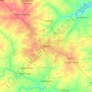
Name: Kano topographic map, elevation, terrain.
Location: Kano, Yakasai, Kano Municipal, Kano State, 700271, Nigeria (11.83400 8.36197 12.15400 8.68197)
Average elevation: 465 m
Minimum elevation: 421 m
Maximum elevation: 534 m
Thank you for supporting this site ❤️
Make a donation
Make a donation
Other topographic maps
Click on a map to view its topography, its elevation and its terrain.