
Thank you for supporting this site ❤️
Make a donation
Make a donation
Aubonne topographic map
Click on the map to display elevation.
Thank you for supporting this site ❤️
Make a donation
Make a donation
About this map
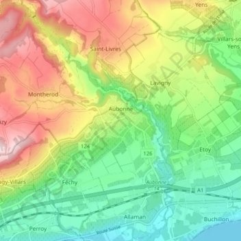
Name: Aubonne topographic map, elevation, terrain.
Location: Aubonne, District de Morges, Vaud, 1170, Suisse (46.47460 6.32736 46.51920 6.40653)
Average elevation: 527 m
Minimum elevation: 374 m
Maximum elevation: 716 m
Thank you for supporting this site ❤️
Make a donation
Make a donation
Other topographic maps
Click on a map to view its topography, its elevation and its terrain.