
Thank you for supporting this site ❤️
Make a donation
Make a donation
Gasteig topographic map
Click on the map to display elevation.
Thank you for supporting this site ❤️
Make a donation
Make a donation
About this map
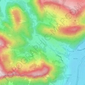
Name: Gasteig topographic map, elevation, terrain.
Average elevation: 913 m
Minimum elevation: 635 m
Maximum elevation: 1,297 m
Thank you for supporting this site ❤️
Make a donation
Make a donation
Other topographic maps
Click on a map to view its topography, its elevation and its terrain.
Kirchdorf
Österreich > Tirol > Bezirk Kitzbühel > Gemeinde Kirchdorf in Tirol
Average elevation: 1,009 m
Thank you for supporting this site ❤️
Make a donation
Make a donation
Oberes Dorf
Österreich > Tirol > Bezirk Kitzbühel > Marktgemeinde St. Johann in Tirol
Average elevation: 711 m
Gemeinde Schwendt
Österreich > Tirol > Bezirk Kitzbühel
Die komplette Liste der Statistik Austria ist in: Topographische Siedlungskennzeichnung nach STAT
Average elevation: 943 m