
Make a donation
Morocco topographic map
Click on the map to display elevation.
Make a donation
Morocco
In the Rif, Middle and High Atlas Mountains, there exist several different types of climates: Mediterranean along the coastal lowlands, giving way to a humid temperate climate at higher elevations with sufficient moisture to allow for the growth of different species of oaks, moss carpets, junipers, and Atlantic fir which is a royal conifer tree endemic to Morocco. In the valleys, fertile soils and high precipitation allow for the growth of thick and lush forests. Cloud forests can be found in the west of the Rif Mountains and Middle Atlas Mountains. At higher elevations, the climate becomes alpine in character, and can sustain ski resorts.
Make a donation
About this map
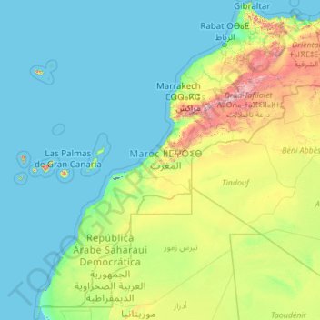
Name: Morocco topographic map, elevation, terrain.
Location: Morocco (20.66725 -17.31902 35.99655 -0.99843)
Average elevation: 277 m
Minimum elevation: -57 m
Maximum elevation: 3,753 m
Make a donation
Other topographic maps
Click on a map to view its topography, its elevation and its terrain.
Atlas Mountains
Morocco > cercle de Taliouine > Toubkal ⵜⵓⴱⵇⴰⵍ توبقال
The Atlas Mountains are a mountain range in the Maghreb in North Africa. It separates the Sahara Desert from the Mediterranean Sea and the Atlantic Ocean; the name "Atlantic" is derived from the mountain range, which stretches around 2,500 km (1,600 mi) through Morocco, Algeria and Tunisia. The range's highest…
Average elevation: 3,402 m
Marrakesh
Morocco > Pachalik de Marrakech > Marrakesh
By road, Marrakesh is located 580 kilometres (360 mi) southwest of Tangier, 327 kilometres (203 mi) southwest of the Moroccan capital of Rabat, 239 kilometres (149 mi) southwest of Casablanca, 196 kilometres (122 mi) southwest of Beni Mellal, 177 kilometres (110 mi) east of Essaouira, and 246 kilometres (153…
Average elevation: 485 m
Ifni Lake
Morocco > Souss-Massa > Cercle de Taliouine > Toubkal ⵜⵓⴱⵇⴰⵍ توبقال
Average elevation: 2,593 m
Douar Jadid F.B.S
Morocco > Béni Mellal-Khénifra > cercle de Fquih Ben Salah دائرة الفقيه بن صالح
Average elevation: 425 m
Make a donation
Parc Écologique d'Oujda
Morocco > Oriental > Pachalik d'Oujda باشوية وجدة > Oujda
Average elevation: 511 m
Toubkal
Morocco > Marrakech-Safi > Cercle d'Asni > Asni
Toubkal, also Jbel Toubkal or Jebel Toubkal, is a mountain in southwestern Morocco, located in the Toubkal National Park. At 4,167 m (13,671 ft), it is the highest peak in Morocco, the Atlas Mountains, North Africa and the Arab world. Located 63 km (39 mi) south of the city of Marrakesh, and visible from it,…
Average elevation: 3,616 m
Make a donation
Make a donation
Ksar Taguersift
Morocco > Drâa-Tafilalet > Cercle d'Agdz > Tamezmoute تامزموت
Average elevation: 904 m
Make a donation
Make a donation
Aït Benhaddou
Morocco > Drâa-Tafilalet > Cercle d'Amerzgane دائرة أمرزكان > Ait Zineb
Average elevation: 1,318 m
Make a donation
Parque del Marxán
Morocco > Tangier-Tetouan-Al Hoceima > Pachalik de Tanger باشوية طنجة > Tangier
Average elevation: 29 m
Make a donation
Rmilet
Morocco > Tangier-Tetouan-Al Hoceima > Pachalik de Tanger باشوية طنجة > Tanger طنجة
Average elevation: 112 m
Dchar Ouattah مدشر وطاح
Morocco > Tangier-Tetouan-Al Hoceima > Cercle de Loukous > Tatoft
Average elevation: 138 m
Beni Habbane
Morocco > Cercle d'Oujda-Banlieue nord دائرة وجدة-الضاحية الشمالية > Ain Sfa
Average elevation: 859 m
Make a donation
Make a donation
Mghayer
Morocco > Tangier-Tetouan-Al Hoceima > Pachalik de Tanger باشوية طنجة > Tangier
Average elevation: 93 m
Oukaïmeden
Morocco > Marrakech-Safi > Cercle de Tahannaout دائرة تحناوت > Oukaimeden
The skiing area is at an altitude of between 2,600 metres (8,500 ft) and 3,200 metres (10,500 ft) and has six ski lifts. There are some hotels and ski rental facilities nearby. Recently oukaimeden is more known of it’s Bouldering potential then the skiing possibilities.
Average elevation: 2,422 m
Make a donation
Atlas Mountains
Morocco > cercle de Taliouine > Toubkal ⵜⵓⴱⵇⴰⵍ توبقال
The Atlas Mountains are a mountain range in the Maghreb in North Africa. It separates the Sahara Desert from the Mediterranean Sea and the Atlantic Ocean; the name "Atlantic" is derived from the mountain range, which stretches around 2,500 km (1,600 mi) through Morocco, Algeria and Tunisia. The range's highest…
Average elevation: 3,402 m
Make a donation
Setti Fatma
Morocco > Cercle de Tahannaout دائرة تحناوت > Sti Fadma > Sti Fadma
Average elevation: 1,874 m
Make a donation
Agoudal ou Souss
Morocco > Souss-Massa > Pachalik d'Ait Meloul ⵍⴱⴰⵛⴰⵡⵉⵢⴰ ⵏ ⴰⵢⵜ ⵎⴻⵍⵍⵓⵍ باشوية ايت ملول > Aït Melloul
Average elevation: 29 m
Make a donation
Anfa Park منتزه أنفا
Morocco > Pachalik de Casablanca باشوية الدار البيضاء > Casablanca
Average elevation: 50 m
Aïn Almou ⵄⵉⵏ ⴰⵍⵎⵓ عين ألمو
Morocco > Cercle d'Oujda-Banlieue nord دائرة وجدة-الضاحية الشمالية > Ain Sfa
Average elevation: 1,285 m
Make a donation
Tanammert
Morocco > Marrakech-Safi > cercle d'Imintanout > Lalla Aaziza > Igrnsouk
Average elevation: 1,108 m
Make a donation
Dar Barroud
Morocco > Tangier-Tetouan-Al Hoceima > Pachalik de Tanger باشوية طنجة > Tangier
Average elevation: 20 m
Haut Atlas Oriental National Park
This site covers 55,252 ha of the High Atlas between Midelt and Er Rachidia. The base rock consists of limestone with some igneous intrusions. The site ranges in altitude from 1,645 m in the bed of the Oued Arheddou to 3,102 m at the summit of Jbel Tanrhourt. At its western end it includes the twin lakes of…
Average elevation: 1,984 m
Azrou أزرو
Morocco > Oriental > Cercle du Rif Nord دائرة الريف الشمالية > Trougout تروكوت
Average elevation: 237 m
Make a donation
Oued El Ogla
Morocco > Casablanca-Settat > Pachalik de El Mansouria > El Mansouria
Average elevation: 15 m
Baie de Nekkour
Morocco > Tangier-Tetouan-Al Hoceima > Ajdir أجدير > Sidi Mohamedi
Average elevation: 21 m
Krimda قريمدة
Morocco > Tangier-Tetouan-Al Hoceima > cercle de Oued El Makhazine دائرة وادي المخازن
Average elevation: 154 m
Sidi Addi
Morocco > Fez-Meknes > Cercle d'Azrou دائرة أزرو > Sidi El Makhfi سيدي المخفي
Average elevation: 1,116 m
Make a donation
Fontaine de Morroco Mall
Morocco > Pachalik de Casablanca باشوية الدار البيضاء > Casablanca
Average elevation: 12 m
Tizert
Morocco > Marrakech-Safi > Cercle de Tahannaout دائرة تحناوت > Sti Fadma
Average elevation: 1,454 m
Quaà Asserasse قـاع أسـراس
Morocco > Tangier-Tetouan-Al Hoceima > Cercle de Bou Ahmed دائرة بو أحمد > Tizgane تزكان
Average elevation: 74 m
Make a donation
Make a donation
Amtoudi
Morocco > Guelmim-Oued Noun > cercle de Bouizakarne دائرة بويزكارن > Amtdi ⴰⵎⵟⴹⵉ امطضي
Average elevation: 1,002 m
Make a donation
Amougar-n-Ait Marghad
Morocco > Cercle de Goulmima دائرة كلميمة > Amellagou املاكو
Average elevation: 1,605 m
Make a donation
Make a donation
Atlas Mountains
Morocco > cercle de Taliouine > Toubkal ⵜⵓⴱⵇⴰⵍ توبقال
The Atlas Mountains are a mountain range in the Maghreb in North Africa. They separate the Sahara Desert from the Mediterranean Sea and the Atlantic Ocean; the name "Atlantic" is derived from the mountain range, which stretches around 2,500 km (1,600 mi) through Morocco, Algeria and Tunisia. The mountains are…
Average elevation: 3,402 m
Plage Blanche ⴰⴼⵜⴰⵙ ⴰⵎⵍⵍⴰⵍ الشاطئ الأبيض
Morocco > Cercle de Laqsabi دائرة القصابي > Echatea El Abied الشاطئ الأبيض > Echatea El Abied
Average elevation: 36 m
Make a donation
Jebel Musa
Morocco > Tangier-Tetouan-Al Hoceima > Cercle de tétouan دائرة تطوان > Belyounech
Average elevation: 353 m
Make a donation
Make a donation