
Lolland topographic map
Interactive map
Click on the map to display elevation.
About this map
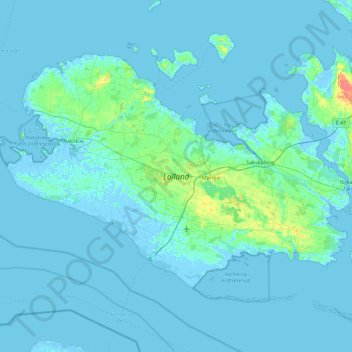
Name: Lolland topographic map, elevation, terrain.
Location: Lolland, Lolland Kommune, Region Seeland, Dänemark (54.59375 10.95471 54.96074 11.86672)
Average elevation: 2 m
Minimum elevation: -6 m
Maximum elevation: 38 m
Other topographic maps
Click on a map to view its topography, its elevation and its terrain.
Omø
Omø, Slagelse Kommune, Region Seeland, 4245, Dänemark
Average elevation: 1 m