
Thank you for supporting this site ❤️
Make a donation
Make a donation
Mont Bellevue topographic map
Click on the map to display elevation.
Thank you for supporting this site ❤️
Make a donation
Make a donation
About this map
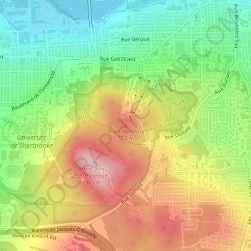
Name: Mont Bellevue topographic map, elevation, terrain.
Location: Mont Bellevue, Sherbrooke, Estrie, Québec, J1H 2B5, Canada (45.37958 -71.91310 45.37968 -71.91300)
Average elevation: 265 m
Minimum elevation: 178 m
Maximum elevation: 365 m
Thank you for supporting this site ❤️
Make a donation
Make a donation
Other topographic maps
Click on a map to view its topography, its elevation and its terrain.
Thank you for supporting this site ❤️
Make a donation
Make a donation
Thank you for supporting this site ❤️
Make a donation
Make a donation