
Make a donation
Stokes State Forest topographic map
Click on the map to display elevation.
Make a donation
Stokes State Forest
The pavilion at the top of the peak makes a great place to picnic. To make traveling to Sunrise more interesting, one can look for the New Jersey shaped rock. The mountain is the second highest point in New Jersey, being 1,653 feet (504 m) above sea level. Hikers are amazed with the view. There is a USGS marker at the top of the mountain which gives the elevation. To get there, the hiking stretch is a quarter of a mile from a parking lot. Much of Sussex County can be seen from the summit of the mountain. From the eastern side of the mountain, one can view the Kittatinny Valley and the Highlands. From the western side, the Delaware Valley and the Port Jervis trough can be seen. From the top of Sunrise Mountain you can see three states, New Jersey, New York, and Pennsylvania.
Make a donation
About this map
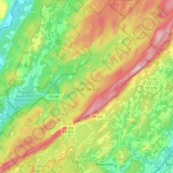
Name: Stokes State Forest topographic map, elevation, terrain.
Average elevation: 260 m
Minimum elevation: 105 m
Maximum elevation: 485 m
Make a donation
Other topographic maps
Click on a map to view its topography, its elevation and its terrain.