
Make a donation
Estepona topographic map
Click on the map to display elevation.
Make a donation
Estepona
Estepona (Spanish pronunciation: [esteˈpona]) is a town and municipality in the comarca of the Costa del Sol, southern Spain. It is located in the province of Málaga, part of the autonomous community of Andalusia. Its district covers an area of 137 square kilometers in a fertile valley crossed by small streams and a mountainous areas dominated by the Sierra Bermeja, which reaches an elevation of 1,449 m at the peak of Los Reales.
Make a donation
About this map
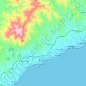
Name: Estepona topographic map, elevation, terrain.
Location: Estepona, Costa del Sol Occidental, Malaga, Andalusia, Spain (36.38613 -5.21967 36.53578 -5.00492)
Average elevation: 265 m
Minimum elevation: -1 m
Maximum elevation: 1,439 m
Make a donation
Other topographic maps
Click on a map to view its topography, its elevation and its terrain.
Make a donation
Make a donation
Make a donation
Casares del Sol
Spain > Andalusia > Costa del Sol Occidental > Casares > Casares del Sol
Average elevation: 41 m
Make a donation
Urbanizacion Playa Mijas
Spain > Andalusia > Costa del Sol Occidental > Urbanización Chaparral > Urbanizacion Playa Mijas
Average elevation: 27 m