
Make a donation
Belihuloya topographic map
Click on the map to display elevation.
Make a donation
Belihuloya
Belihuloya is a village in the Ratnapura District, Sabaragamuwa Province of Sri Lanka. It is approximately 150 kilometres (93 mi) south-east of Colombo and is situated at an elevation of 616 metres (2,021 ft) above sea level. This hillside location is a climatically transitional area, linking both the dry and wet zones and the hill and low country. Belihuloya is derived from the Belih Oya ("Oya" being the Sinhala word for river), which flows through the area.
Make a donation
About this map
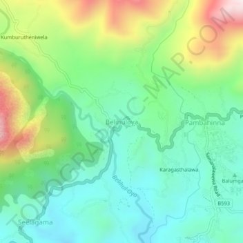
Name: Belihuloya topographic map, elevation, terrain.
Average elevation: 705 m
Minimum elevation: 462 m
Maximum elevation: 1,232 m
Make a donation
Other topographic maps
Click on a map to view its topography, its elevation and its terrain.
Sinharaja Forest Reserve
Sri Lanka > Sabaragamuwa Province > Palinda-Nuwara (Baduraliya) DS Division
Average elevation: 374 m
Make a donation
Make a donation
Sinharaja Forest Reserve
Sri Lanka > Sabaragamuwa Province > Palinda-Nuwara (Baduraliya) DS Division
Average elevation: 374 m
Sinharaja Forest Reserve
Sri Lanka > Sabaragamuwa Province > Palinda-Nuwara (Baduraliya) DS Division
Average elevation: 374 m
Make a donation