
Dothémare topographic map
Interactive map
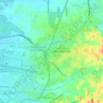
Click on the map to display elevation.
About this map
Name: Dothémare topographic map, elevation, terrain.
Average elevation: 18 m
Minimum elevation: 1 m
Maximum elevation: 61 m
Other topographic maps
Click on a map to view its topography, its elevation and its terrain.
Boisvin
France > Guadeloupe > Les Abymes
Boisvin, Les Abymes, Pointe-à-Pitre, Guadeloupe, 97139, France
Average elevation: 40 m
Chazeau
France > Guadeloupe > Les Abymes
Chazeau, Les Abymes, Pointe-à-Pitre, Guadeloupe, 97111, France
Average elevation: 34 m
Caraque
France > Guadeloupe > Les Abymes
Caraque, Les Abymes, Pointe-à-Pitre, Guadeloupe, 97139, France
Average elevation: 40 m