
Thank you for supporting this site ❤️
Make a donation
Make a donation
Chain O'Lakes State Park topographic map
Click on the map to display elevation.
Thank you for supporting this site ❤️
Make a donation
Make a donation
About this map
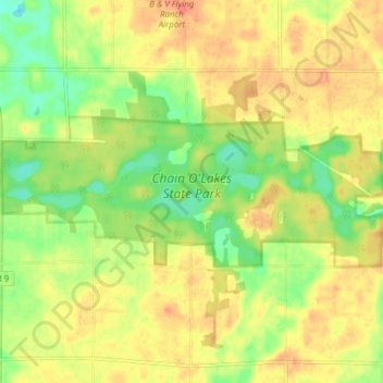
Name: Chain O'Lakes State Park topographic map, elevation, terrain.
Average elevation: 290 m
Minimum elevation: 264 m
Maximum elevation: 309 m
Thank you for supporting this site ❤️
Make a donation
Make a donation
Other topographic maps
Click on a map to view its topography, its elevation and its terrain.
Kendallville
United States > Indiana > Noble County > Kendallville > Kendallville
Average elevation: 304 m
Thank you for supporting this site ❤️
Make a donation
Make a donation