
Thank you for supporting this site ❤️
Make a donation
Make a donation
Hötzelsroda topographic map
Click on the map to display elevation.
Thank you for supporting this site ❤️
Make a donation
Make a donation
Hötzelsroda
Die geographische Höhe des Hauptortes beträgt 290 m ü. NN.
Thank you for supporting this site ❤️
Make a donation
Make a donation
About this map
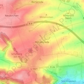
Name: Hötzelsroda topographic map, elevation, terrain.
Average elevation: 295 m
Minimum elevation: 224 m
Maximum elevation: 337 m
Thank you for supporting this site ❤️
Make a donation
Make a donation
Other topographic maps
Click on a map to view its topography, its elevation and its terrain.