
Kanakpura topographic map
Interactive map
Click on the map to display elevation.
About this map
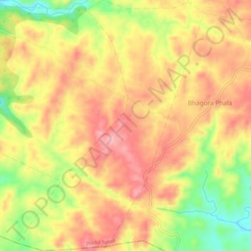
Name: Kanakpura topographic map, elevation, terrain.
Location: Kanakpura, Jhadol Tehsil, Udaipur District, Rajasthan, India (24.14677 73.42787 24.18606 73.46003)
Average elevation: 556 m
Minimum elevation: 460 m
Maximum elevation: 621 m
Other topographic maps
Click on a map to view its topography, its elevation and its terrain.
Sagpura
India > Rajasthan > Jhadol Tehsil
Sagpura, Jhadol Tehsil, Udaipur District, Rajasthan, India
Average elevation: 536 m
Kunda
India > Rajasthan > Jhadol Tehsil
Kunda, Jhadol Tehsil, Udaipur District, Rajasthan, India
Average elevation: 507 m
Kundal
India > Rajasthan > Jhadol Tehsil > Kundal
Kundal, Jhadol Tehsil, Udaipur District, Rajasthan, India
Average elevation: 667 m
Kherad
India > Rajasthan > Jhadol Tehsil
Kherad, Jhadol Tehsil, Udaipur District, Rajasthan, India
Average elevation: 542 m