
Fort Kent topographic map
Interactive map
Click on the map to display elevation.
About this map
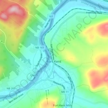
Name: Fort Kent topographic map, elevation, terrain.
Location: Fort Kent, Aroostook County, Maine, United States (47.23774 -68.61080 47.28634 -68.56132)
Average elevation: 217 m
Minimum elevation: 148 m
Maximum elevation: 367 m
Other topographic maps
Click on a map to view its topography, its elevation and its terrain.
Fort Kent Mills
United States > Maine > Aroostook County > Fort Kent
Fort Kent Mills, Fort Kent, Aroostook County, Maine, 04743, United States
Average elevation: 213 m
Saint John River
United States > Maine > Aroostook County > Fort Kent
Saint John River, Fort Kent, Aroostook County, Maine, United States
Average elevation: 208 m