
Thank you for supporting this site ❤️
Make a donation
Make a donation
Komani topographic map
Click on the map to display elevation.
Thank you for supporting this site ❤️
Make a donation
Make a donation
About this map
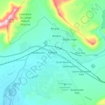
Name: Komani topographic map, elevation, terrain.
Average elevation: 1,147 m
Minimum elevation: 1,031 m
Maximum elevation: 1,608 m
Thank you for supporting this site ❤️
Make a donation
Make a donation
Other topographic maps
Click on a map to view its topography, its elevation and its terrain.
Komani
South Africa > Eastern Cape > Chris Hani District Municipality > Lukhanji Local Municipality > Komani
Average elevation: 1,064 m