
Lüdenscheid topographic map
Interactive map
Click on the map to display elevation.
About this map
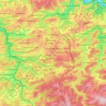
Name: Lüdenscheid topographic map, elevation, terrain.
Average elevation: 384 m
Minimum elevation: 161 m
Maximum elevation: 587 m
Other topographic maps
Click on a map to view its topography, its elevation and its terrain.
Altena
Allemagne > Rhénanie-du-Nord-Westphalie > Märkischer Kreis > Altena > Altena
Altena, Märkischer Kreis, Rhénanie-du-Nord-Westphalie, 58762, Allemagne
Average elevation: 342 m