
Yaoundé IV topographic map
Interactive map
Click on the map to display elevation.
About this map
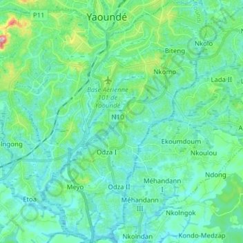
Name: Yaoundé IV topographic map, elevation, terrain.
Location: Yaoundé IV, CUY, Mfoundi, CE, Cameroun (3.75175 11.48716 3.87747 11.57301)
Average elevation: 710 m
Minimum elevation: 661 m
Maximum elevation: 949 m
Other topographic maps
Click on a map to view its topography, its elevation and its terrain.