
Thank you for supporting this site ❤️
Make a donation
Make a donation
Cuenca topographic map
Click on the map to display elevation.
Thank you for supporting this site ❤️
Make a donation
Make a donation
Cuenca
The climate of Cuenca is the typical hot-summer Mediterranean climate of Spain's "Meseta" (inner plateau). Winters are relatively cold, but summers are quite hot during the day with occasional cool nights. Spring and autumn seasons are short, with pleasant temperatures during the day but with rather cold nights due to its altitude from 956 m (3,136 ft) above sea level up to 1,000 m (3,281 ft) in the old town.
Thank you for supporting this site ❤️
Make a donation
Make a donation
About this map
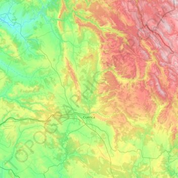
Name: Cuenca topographic map, elevation, terrain.
Location: Cuenca, Castile-La Mancha, Spain (39.82644 -2.35502 40.52300 -1.69724)
Average elevation: 1,124 m
Minimum elevation: 689 m
Maximum elevation: 1,915 m
Thank you for supporting this site ❤️
Make a donation
Make a donation
Other topographic maps
Click on a map to view its topography, its elevation and its terrain.
Thank you for supporting this site ❤️
Make a donation
Make a donation
Thank you for supporting this site ❤️
Make a donation
Make a donation
Thank you for supporting this site ❤️
Make a donation
Make a donation
Thank you for supporting this site ❤️
Make a donation
Make a donation
Thank you for supporting this site ❤️
Make a donation
Make a donation
Thank you for supporting this site ❤️
Make a donation
Make a donation
Thank you for supporting this site ❤️
Make a donation
Make a donation
Thank you for supporting this site ❤️
Make a donation
Make a donation
Thank you for supporting this site ❤️
Make a donation
Make a donation
Thank you for supporting this site ❤️
Make a donation
Make a donation