
Thank you for supporting this site ❤️
Make a donation
Make a donation
Gellersen topographic map
Click on the map to display elevation.
Thank you for supporting this site ❤️
Make a donation
Make a donation
About this map
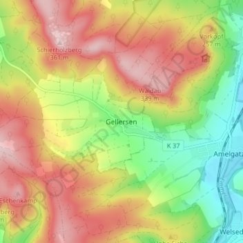
Name: Gellersen topographic map, elevation, terrain.
Average elevation: 217 m
Minimum elevation: 80 m
Maximum elevation: 349 m
Thank you for supporting this site ❤️
Make a donation
Make a donation
Other topographic maps
Click on a map to view its topography, its elevation and its terrain.
31855
Deutschland > Niedersachsen > Landkreis Hameln-Pyrmont > Aerzen > Königsförde
Average elevation: 188 m
Humme
Deutschland > Niedersachsen > Landkreis Hameln-Pyrmont > Aerzen
Die Quellbäche der Humme, Hummerbach und Dewesiek, entspringen im nordrhein-westfälischen Naturpark Teutoburger Wald/Eggegebirge südwestlich der Hohen Asch (371,5 m ü. NHN) beim Extertaler Weiler Hummerbruch. Die Quelle des linksseitigen Hummerbachs, auf den sich die Hummekilometrierung bezieht, liegt auf…
Average elevation: 161 m