
Thank you for supporting this site ❤️
Make a donation
Make a donation
Craigmore topographic map
Click on the map to display elevation.
Thank you for supporting this site ❤️
Make a donation
Make a donation
Craigmore
Adams Creek runs through the middle of Craigmore, with an elevation of the suburb ranging from 86 to 149 meters at its highest point.
Thank you for supporting this site ❤️
Make a donation
Make a donation
About this map
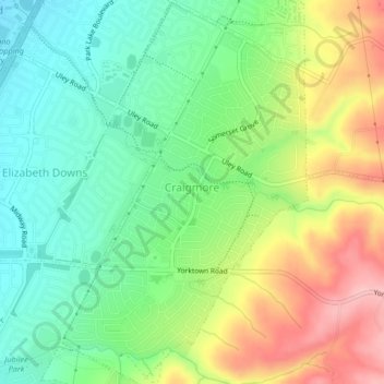
Name: Craigmore topographic map, elevation, terrain.
Average elevation: 118 m
Minimum elevation: 56 m
Maximum elevation: 215 m
Thank you for supporting this site ❤️
Make a donation
Make a donation